🥾 Martha’s Vineyard Hiking Guide: Favorite Trails by Town
MVacay's personal favorites, options that are dog-accessible, stroller-friendly, and where to find the best views
I’ve written guides for beaches, biking, e-bikes, and outdoor sports, but hiking on MV is such a great way to see the island from a new perspective (especially during the fall!). This post is your curated list of my favorite hikes and walks across all six towns, organized by location.
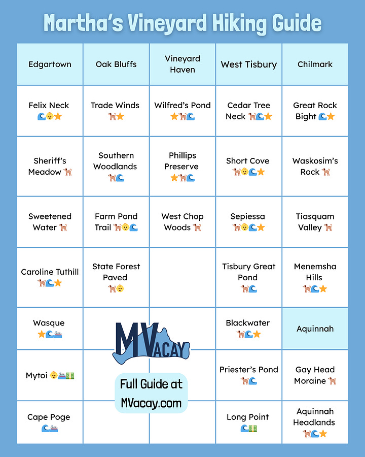
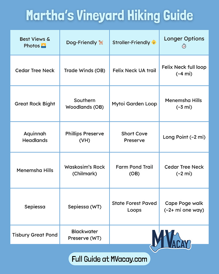
I’ve included what’s stroller-friendly👶, dog-accessible🐕, and where to find the best views🌊. This isn’t a full master list of every path and preserve on the island, but a visitor-friendly selection that:
Is generally under 3 miles one way (easy to moderate)
Offers notable scenery, history, or accessibility features
Has maintained trails and clear public access
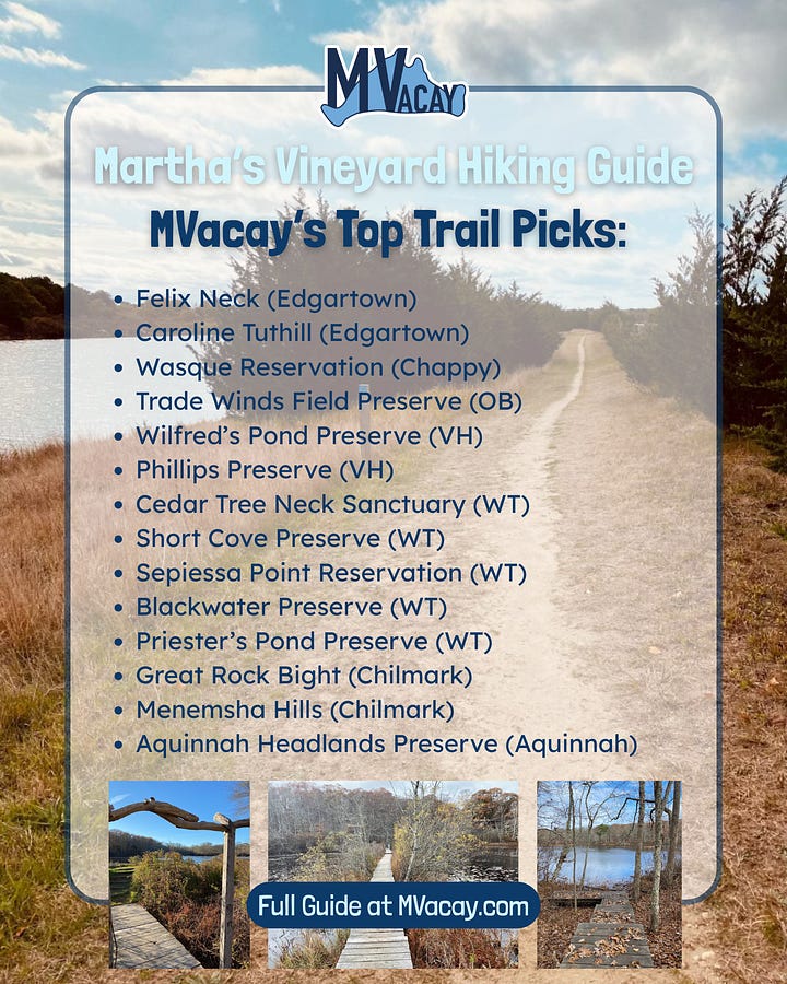
I’ve also starred my ⭐family’s personal favorites below!
Edgartown
Felix Neck Wildlife Sanctuary 🌊👶⭐
📍 100 Felix Neck Drive / Managed by Mass Audubon
Mileage: ~4 miles total
Terrain: Woods, meadows, shoreline
Accessibility: No dogs; 1-mile Universal Access trail
Notable: Birdwatching, salt marsh and pond views
Sheriff’s Meadow Sanctuary 🐕
📍 Off Planting Field Way / Managed by Sheriff’s Meadow Foundation
Mileage: ~0.5–1 mile
Terrain: Pondside and wooded trails
Accessibility: Dogs allowed on leash; easy terrain
Notable: Central location, quiet and shaded
Sweetened Water Preserve 🐕
📍 Near Meetinghouse Way / Managed by Sheriff’s Meadow Foundation
Mileage: ~0.5–1 mile loop
Terrain: Woods and open fields
Accessibility: Dogs allowed; easy terrain
Notable: Peaceful, close to downtown
Caroline Tuthill Preserve 🐕🌊⭐
📍 Off Edgartown–Vineyard Haven Road / Managed by Sheriff’s Meadow Foundation
Mileage: ~1.5 miles
Terrain: Mixed woods and wetlands
Accessibility: Dogs allowed; easy terrain
Notable: Convenient location with diverse habitats, views of salt marshes, pond & State Beach
Chappaquiddick (part of Edgartown, accessed by the On Time Ferry):
Wasque Reservation ⭐🌊⛴️💵
📍 Off Pocha Road / Managed by Trustees of Reservations
Mileage: ~1–2 miles
Terrain: Sandplain grassland, shoreline
Accessibility: No dogs; seasonal closures
Notable: Remote, peaceful
Mytoi Garden + Forest Loop 👶⛴️💵
📍 Dike Road / Managed by Trustees of Reservations
Mileage: ~0.5–1 mile
Terrain: Gravel garden paths, shaded forest
Accessibility: No dogs in garden; stroller-friendly, paid entry in season
Notable: Japanese-style garden
Cape Poge Wildlife Refuge (walking route) 🌊⛴️💵
📍 Start at Dike Bridge / Managed by Trustees of Reservations
Mileage: ~2+ miles one way
Terrain: Beach and dune walking
Accessibility: No dogs; remote
Notable: Birdwatching, solitude
Other Edgartown Options: Cape Poge lighthouse area ⛴️, Edgartown Great Pond Trail 🌊, Poucha Pond Reservation (Chappy) ⛴️
Oak Bluffs
Trade Winds Field Preserve 🐕 ⭐
📍 County Road / Managed by MV Land Bank
Mileage: ~1–1.5 miles
Terrain: Open fields, meadows, forest edges
Accessibility: Dogs allowed off-leash under voice control
Notable: Popular dog-walking spot
Southern Woodlands 🐕🌊
📍 Barnes Road (near YMCA) / Managed by MV Land Bank
Mileage: ~2 miles
Terrain: Old carriage roads, woods
Accessibility: Dogs allowed; moderate terrain
Notable: Lagoon Pond views
Farm Pond Trail 🐕👶🌊
📍 Seaview Ave / Managed by Town of Oak Bluffs
Mileage: ~0.5 mile
Terrain: Short shoreline walk
Accessibility: Dogs allowed; stroller-friendly
Notable: Pond views, beach views
State Forest Paved Trails 🐕👶
📍 Multiple access points / Managed by DCR – Manuel F. Correllus State Forest
Mileage: ~3+ miles paved loops
Terrain: Flat, paved multi-use path
Accessibility: Dog- and stroller-friendly; great for bikes
Notable: Shaded stretches, safe off-road route
Other Oak Bluffs Options: Featherstone Farm Path, East Chop Bluff Walk 🌊, Farm Neck Land Bank Parcels
Vineyard Haven / Tisbury
Wilfred’s Pond Preserve ⭐🐕🌊
📍 Stonegate Lane / Managed by MV Land Bank
Mileage: ~1 mile
Terrain: Wooded
Accessibility: Dogs allowed; not stroller-friendly
Notable: Small, quiet, opens to beach, great for sunsets
Phillips Preserve ⭐🐕🌊
📍 Off Winyah Lane / Managed by Sheriff’s Meadow Foundation
Mileage: ~1 mile loop
Terrain: Woods, pond, light beach access
Accessibility: Dogs allowed; easy terrain
Notable: Peaceful, scenic
Other Vineyard Haven Options: Tisbury Meadow Preserve, Lagoon Pond Beach Walk 🌊, Veterans Park Path
West Tisbury
Cedar Tree Neck Sanctuary 🐕🌊 ⭐
📍 210 Obed Daggett Road / Managed by Sheriff’s Meadow Foundation
Mileage: ~2 miles
Terrain: Meadows, forest, beach
Accessibility: Dogs allowed; moderate terrain
Notable: Remote, varied landscape, opens to beach, bluff views of Vineyard Sound
Short Cove Preserve 🐕👶🌊 ⭐
📍 85 Tiah’s Cove Road / Managed by MV Land Bank
Mileage: ~1 mile
Terrain: Flat dirt path with pond views
Accessibility: Dogs allowed; stroller-friendly
Notable: Open water views
Sepiessa Point Reservation 🐕👶🌊 ⭐
📍 Off New Lane / Managed by MV Land Bank
Mileage: ~1.5–2 miles
Terrain: Flat trails along pond
Accessibility: Dogs allowed; easy terrain
Notable: Pond access, sunsets
Tisbury Great Pond Trail 🐕🌊
📍 Pond access via Deep Bottom Road / Managed by MV Land Bank
Mileage: ~1–1.5 miles
Terrain: Flat, coastal pondside
Accessibility: Dogs allowed; easy terrain
Notable: Great for birdwatching and quiet walks
Blackwater Preserve 🐕🌊 ⭐
📍 State Road / Managed by MV Land Bank
Mileage: ~1–1.5 miles
Terrain: Woods and wetland edges
Accessibility: Dogs allowed; easy to moderate terrain
Notable: Shaded and uncrowded, pond views
Long Point Wildlife Refuge 🌊💵
📍 330 Long Point Road / Managed by Trustees of Reservations
Mileage: ~2 miles
Terrain: Woods and beach
Accessibility: No dogs; entry fee in summer
Notable: Birdwatching, expansive beach/pond views
Priester’s Pond Preserve 🐕🌊
📍 Lambert’s Cove Road / Managed by MV Land Bank
Mileage: ~1 mile
Terrain: Meadow paths, wooded edges, pond access
Accessibility: Dogs allowed; easy terrain
Notable: Quiet, scenic walk with open views of the pond, good for birdwatching
Other West Tisbury Options: John Presbury Norton Farm, Manaquayak Preserve, Ripley’s Field Preserve
Chilmark
Great Rock Bight 🌊⭐
📍 37 Brickyard Road / Managed by MV Land Bank
Mileage: ~1.5 miles
Terrain: Fields, woods, steep bluff stairs
Accessibility: Dogs allowed Oct–Mar only; limited parking
Notable: Bluff overlook, beach below
Waskosim’s Rock Reservation 🐕
📍 South Road / Managed by MV Land Bank
Mileage: ~1.5 miles
Terrain: Forest, meadows, streams
Accessibility: Dogs allowed; moderate terrain
Notable: Historic boulders
Tiasquam Valley Reservation 🐕
📍 South Road or Meetinghouse Road / Managed by Sheriff’s Meadow Foundation
Mileage: ~1.5 miles
Terrain: Forest, riverside
Accessibility: Dogs allowed; easy to moderate terrain
Notable: Quiet, shaded
Menemsha Hills 🐕🌊⭐
📍 North Road / Managed by Trustees of Reservations
Mileage: ~3 miles total
Terrain: Woods, bluffs, beach access
Accessibility: Dogs allowed on leash; moderate terrain
Notable: Panoramic views of Vineyard Sound
Other Chilmark Options: Peaked Hill 🌊, Middle Road Sanctuary
Aquinnah
Gay Head Moraine 🐕
📍 State Road, across from Moshup Trail / Managed by MV Land Bank
Mileage: ~1 mile
Terrain: Steep forest trail
Accessibility: Dogs allowed; rugged terrain
Notable: Rare plants, glacial landscape
Aquinnah Headlands Preserve 🐕🌊⭐
📍 Near Aquinnah Circle / Managed by Town of Aquinnah
Mileage: ~1 mile
Terrain: Coastal shrubland
Accessibility: Dogs allowed; exposed trail
Notable: Clifftop ocean views
Other Aquinnah Options: Moshup Beach Walk 🌊, Lobsterville Beach Path 🌊
📚 More Resources
If you’re looking for more trails, there are dozens more if you dig into the resources below. For detailed maps, trail rules, and seasonal updates:
Our favorite hard copy pocket guide is the latest ‘Walking Trails of Martha's Vineyard: A Comprehensive Pocket Guide to Public Conservation Areas by William Flender’ available at on-island booksellers - we advise you to take a picture with your phone of the trail map when listed if you don’t have access to a guide.
The free TrailsMV app, created by Sheriff’s Meadow Foundation is an interactive guide to 220+ miles of public trails on more than 100 protected properties. Download it before your trip for maps, parking info, and property details.
⚠️ Trail Safety Notes:
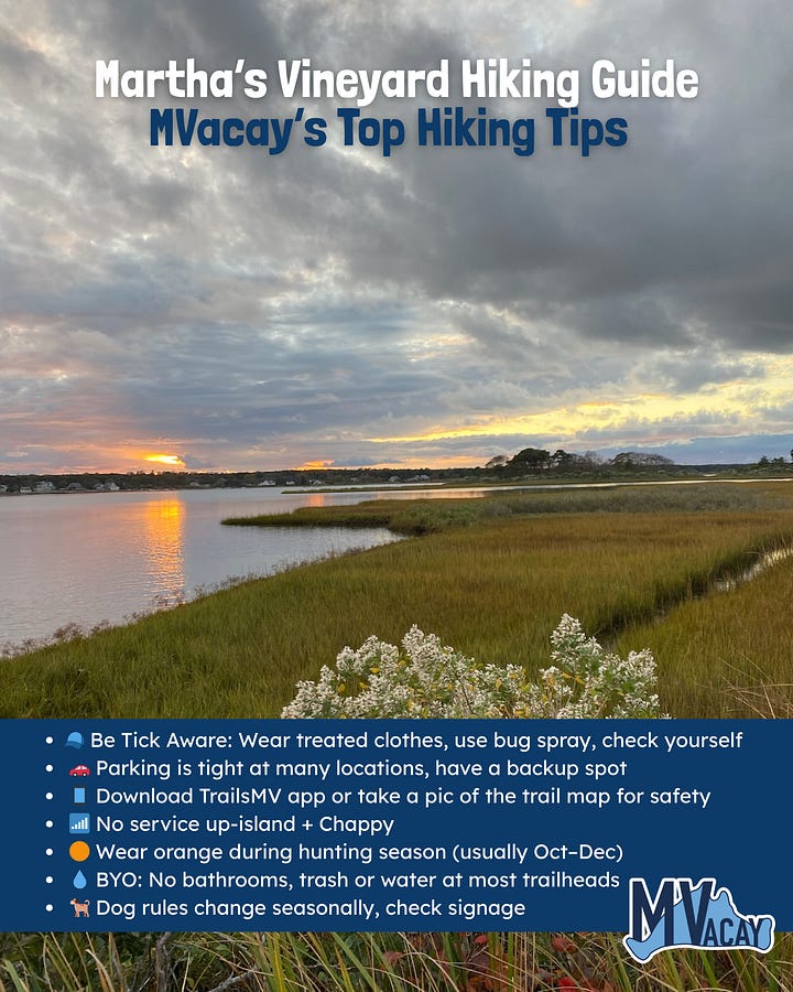
Ticks: MV has a high prevalence of ticks, including species that carry Lyme disease or other tick-borne illnesses. Stay on marked trails, use repellent, wear treated clothing, and check yourself (and pets) carefully after every hike.
Hunting Season: Hunting is allowed on some island properties from early October through the end of December (varies by type). Wear blaze orange if you’re hiking during these months, even on properties where hunting is prohibited, as boundaries can be close. Sunday is the only no-hunting day in Massachusetts.
Pet-Friendly Notes: Most trails on MV are seasonal access only. Many trails and beaches restrict dogs between April–September (sometimes May–September, depending on the property). Signs at each trailhead will tell you the current rule.
Cell Service: Many areas, especially on Chappaquiddick and up-island, have little to no cell coverage. Download maps in advance and let someone know your plan if you’re hiking more remote trails.
Happy hiking, be safe, and respect nature! 🌿




Happy trails!